Canada
Federal government rolls out new colour-coded weather alert system for Canada
Environment and Climate Change Canada meteorologists have launched a new colour-coded weather alert system across the country, arguing it will better convey risks and impacts to communities.
The new tri-coloured weather alerting system came into effect on Wednesday. It replaced a system that had two colours: red for warnings (accompanied by a message about urgent impacts of weather occurring at the moment or set to occur imminently) and yellow for watches (usually about conditions that could result in severe weather).
Watches and warnings will still be issued under the new weather alert system, but will be accompanied by one of three colours that officials said will better align with impact:
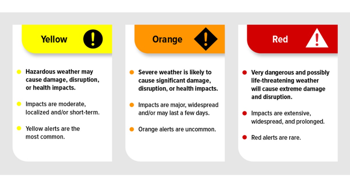
- Red -set to be used rarely, tied to prolonged and widespread impact, “very dangerous” weather that’s potentially life-threatening and “will cause extreme damage and disruption”
- Orange -uncommon to be used, impacts to be “major, widespread and/or may last a few days,” likely to cause “significant damage, disruption or health impacts”
- Yellow – most common of alerts to be used, impacts to be “moderate, localized and/or short-term,” advises hazardous weather “may cause damage, disruption, or health impacts”
There are 14 common Canadian weather events and hazards that will be covered under the new alert system:
- Coastal flooding and storm surges
- Cold
- Frost
- Heat
- Hurricanes and tropical storms
- Ice (including flash freeze, freezing drizzle, freezing rain)
- Rain
- Snow
- Snow squalls
- Thunderstorms
- Tornadoes
- Visibility (including blizzards, blowing snow, fog)
- Wind
- Winter storm
Watches and warnings may have additional information on general, travel, human health and societal recovery impacts as well as the impact to utilities, public services, land and structures.
Jesse Wagar, an Environment and Climate Change Canada warning preparedness meteorologist, told CityNews the new tri-coloured system is meant to better align with meteorological best practices.
“It really is this whole-scale shift to impact-based forecasting and alerts, and not just threshold-based forecasting and alerts,” she said.
“It’s the risk level that’s associated with the forecast weather event that includes that assessment of the potential impact, the confidence of our meteorologists in the forecast, and then the weather alert colour reflects that assessment.”

Meanwhile, special weather statements (often displayed on Environment and Climate Change Canada maps as grey) will continue to be used under the new system. The agency classified these statements as the least urgent form of messaging. The statements typically advise of uncommon conditions and the potential for concern.
CityNews will utilize information from the new alert system in its reporting about severe weather events on broadcast and online channels.
Natasha Ramsahai, chief meteorologist for CityNews, said the incoming alert system will take some getting used to and will require a public education campaign to help people understand it and not get lost in the details, but noted that there are potential benefits.
She used a summertime rain event to illustrate how the system could provide additional context.
“The criteria is for any rainfall over 50 millimetres, so 50 millimetres in Toronto falling over eight hours … there’s no way to discern that rainfall warning from a rainfall warning that’s 300 millimetres from the remnants of a hurricane that’s crossing over Toronto,” Ramsahai said.
“I think it is a good way for the three-tier system to disseminate between a light rainfall that’s still kind of meeting the criteria and one that could potentially be really damaging and dangerous and potentially life-threatening.”