Local News
Rainfall expected to break records during weather event
Rain will continue battering Metro Vancouver through to Sunday as the area sees its first major storm of the season, and Environment Canada says it is expected to break several records.
Morgen Shull with the weather service says an all-time rainfall record for 24 hours is expected for Langley. Already, 117.4 millimetres have fallen in that municipality, just shy of the previous record of 117.8 mm, with more to come. As well, Shull says a rainfall record for the date of Oct. 19 is expected at YVR. The previous record was 59.7 mm in 1956, but the total for today is not yet available. Other records are also likely to be broken
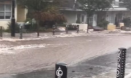
Several parts of the Lower Mainland are seeing flooding and deep water flowing through the streets. In Deep Cove, water rushing down one of the streets looked like a river flowing past houses in a residential area.
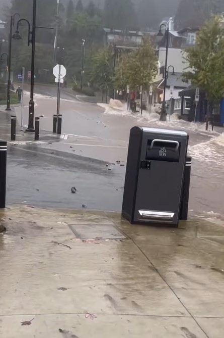
Water flowing down a side street in Deep Cove during an atmospheric river Oct. 19, 2024. (Image: Honeys Doughnuts, @papa_beggs via Instagram)
Relief is in sight, however.
“The heaviest rain is expected to taper off by between 8 to 10 p.m. tonight. However, rain is expected to continue overnight tonight and continue through Sunday,” Shull said.
“An additional 10 to 20 mm is expected for today, 10 to 20 mm for tonight, and 10 to 20 mm for Sunday.”
These amounts will vary by location. The North Shore mountains, for example, are expected to see higher amounts.
“The atmospheric river still has its sights set on the South Coast, although the heaviest bands of precipitation have already slid through the area and are either east or dropping down to the south,” said 1130 NewsRadio meteorologist Michael Kuss.
“That said, even with lighter rain through the afternoon, more bands of substantial precipitation are developing this evening and overnight. I wouldn’t be surprised if we saw an additional 30 to 50 mm of precipitation before the system exits parts of the Lower Mainland.”
Kuss says the North Shore has seen rain falling at rates of greater than 10 mm per hour for five-plus hours.
“Rainfall just from midnight through to noon was between 70 and 100 mm in much of Metro Vancouver just for Saturday — not including the Friday totals,” he said.
“Over 50 mm and a widespread 30 mm fell on Friday.”
1130 NewsRadio reporter Srushti Gangdev shared an update on the situation near Boundary Road where it crosses into North Burnaby.
“What I’m seeing is really, widely variable,” she said. There’s tons of wind blowing around, but then as soon as you cross over into boundary, which is only a few blocks away, that rain is just pounding down.”
Gangdev mentioned hearing about a neighbour with a flooded basement.
“It’s possible we could see insurance claims being made in the next day or two.”
In the Still Creek Area, where significant flooding has been reported, construction sites appear to have been affected.
“I could see cables and things just flying up in the wind from some of these skyscrapers that are under construction,” she said.
Environment Canada warns of swollen rivers and creeks and minor coastal flooding.
“Heavy downpours can cause flash floods and water pooling on roads,” the weather service said.
“Localized flooding in low-lying areas is possible.
A highway alert has also been issued for the Coquihalla Highway between Hope and Merritt.
Listen live to 1130 NewsRadio Vancouver weather updates every 10 minutes after traffic on the ones. You can also follow Meteorologist Michael Kuss on X and subscribe to breaking news alerts sent directly to your inbox.